
Ridges & Summits
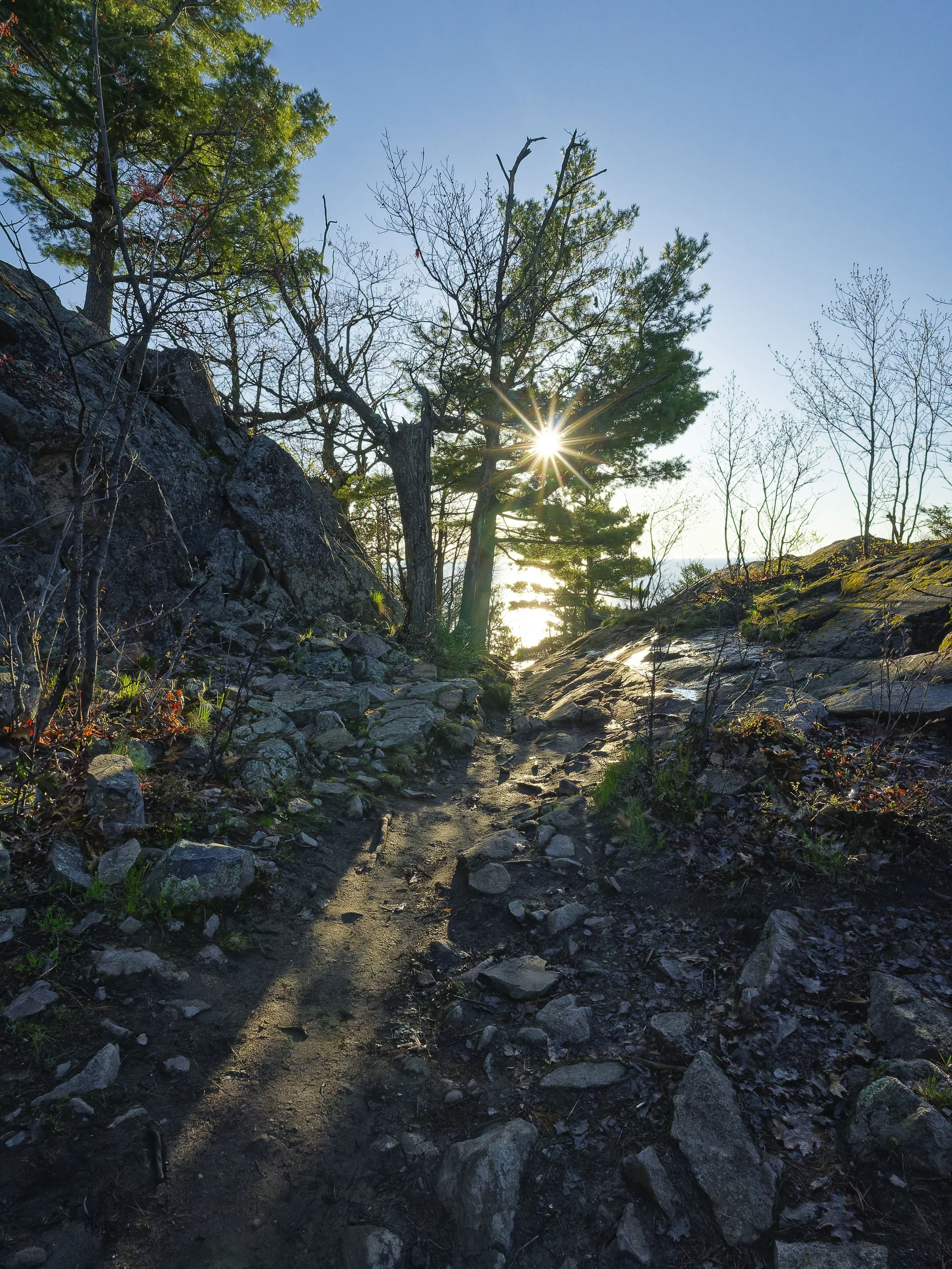
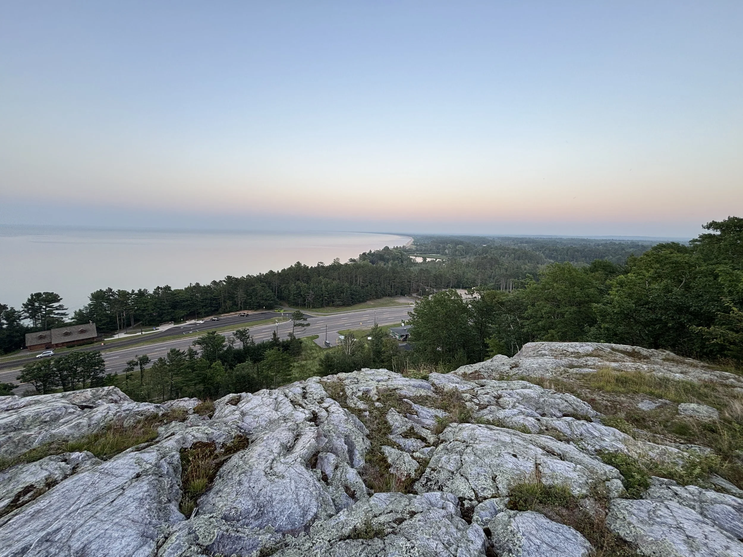
Sugarloaf
Sugarloaf Sunrise. Photo by Tony Pelletier.
If you only have time for one hike in Marquette, this is it. Sugarloaf is one of the area's most iconic landmarks, offering the ultimate "bang for your buck" when it comes to views. A short but rewarding climb leads you to a series of wooden observation platforms where the world opens up, revealing a breathtaking 360-degree vista of the Lake Superior coastline, the city of Marquette, and the rolling hills of the Huron Mountains.
-
This is a "choose your own adventure" climb. We can take the "Easy" route, which is a longer, winding path with a gentle grade, or the "Moderate" route, which is a more direct, steeper ascent. Both paths converge near the top for the final climb.
-
We maintain a consistent, rhythmic pace to tackle the elevation. While the hike is relatively short, it is a vertical gain, so we keep moving steadily to reach the summit while leaving plenty of breath for the "wow" moment at the top.
-
The well-maintained trail system features solid forest paths and a significant number of wooden stairs as you approach the summit. For those feeling more adventurous, there are sections of natural rock outcroppings we can navigate to get that true mountain feel.
-
The summit is the star of the show. You'll stand on ancient rock outcrops overlooking the vast blue of Lake Superior, the distant view of Marquette, and the endless green canopy of the U.P. wilderness.
-
To create the ultimate Little Presque Isle day, Sugarloaf is best paired with Wetmore Landing for a beach-level contrast to your summit views, or Hogback if you want to see Sugarloaf’s bigger, more rugged neighbor from across the valley.
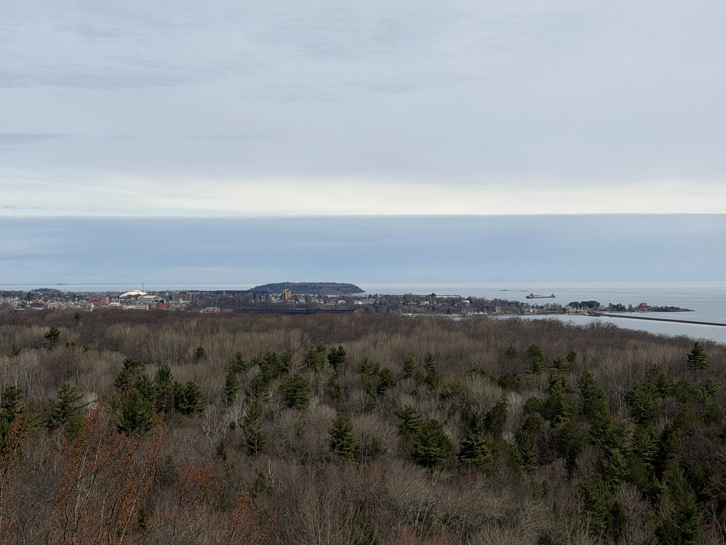
Mt. Marquette
Mount Marquette View. Photo by Tony Barnes.
Rising 1,200 feet above sea level, Mt. Marquette offers the definitive panoramic view of the Marquette harbor, the ore docks, and the vast expanse of Lake Superior. This hike skips the dusty driving road in favor of the hiking trails. We’ll climb through dense hardwoods and across ancient rock outcrops to reach the overlook with hidden granite perches that offer 270-degree views of the Iron Range and the city below.
-
This location involves a noticeable climb. We’ll be gaining elevation quickly, which requires a bit of stamina, but the payoff at the summit makes every step worth the effort.
-
Mt. Marquette is deceivingly tough to summit. People think its easy because they can take the road but its way more fun to take the trails and rocks. This is a great choice for those who want to feel the work in their legs and enjoy a productive hike that leads to an incredible visual reward.
-
The vertical-focused nature of the hike emphasizes elevation gain and panoramic payoffs over the specific route you choose. We’ll navigate narrow forest footpaths and eventually move onto the exposed rock outcrops that form the mountain's crest.
-
Stand atop Precambrian rock that has stood for billions of years while enjoying a bird's-eye view of the Marquette skyline, the Lower Harbor Ore Dock, and the distant horizon of the Great Lake.
-
If you get to the top and you’re ready to see more of what Marquette has to offer, you can easily drop down the other side of the mountain instead of looping back to your vehicle right away. Or, you can take it easy and head into downtown Marquette to walk the historic streets you just viewed from the summit.
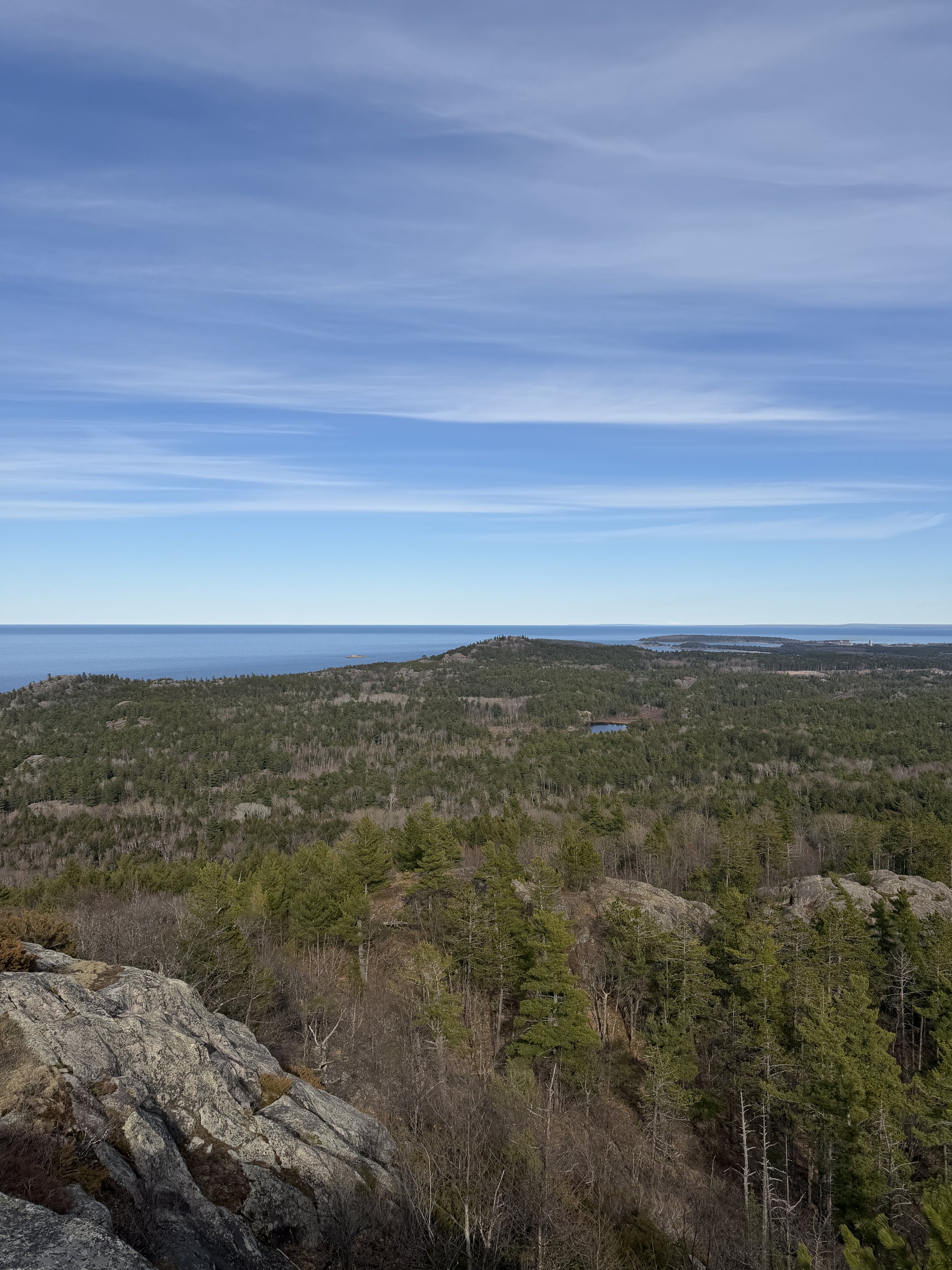
Hogback
Hogback Vista. Photo by Tony Barnes.
The Hogback loop is a steep, forested mountain climb that rises quickly out of the surrounding landscape to deliver wide, open views of Marquette, Lake Superior, and the rolling inland hills of the Huron Mountains. The ascent is short but sustained, with a rugged feel underfoot and sections of exposed rock that reflect the area’s glacial geology. Once on top the route opens into a series of overlooks that reward the effort with a strong sense of elevation. People get lost in this area of forest every year so hiring a guide is your safest way to the summit.
-
This is a high-effort trek that requires physical stamina and a steady foot. The final approach to the summit involves significant elevation gain over short distances, demanding more of your lungs and legs than any other local hike.
-
The forest canopy approach and return is a maze while the climb includes some dexterity on the rock faces. We maintain a focused, energetic clip to navigate the miles through the forest before tackling the climb. This pace is designed for those who enjoy a physical challenge and want to experience the thrill of a high-energy mountain ascent.
-
The hike is relatively short but is physically demanding because of the nature of the climb, especially if you can’t help yourself from climbing the rocky outcrops you encounter along the way.
-
The reward is unmatched: a jagged granite peak with unobstructed views for miles in every direction. Along the way, we’ll also pass the hidden, tranquil Potluck Falls, providing a cool forest contrast to the rugged summit.
-
Wetmore Landing is literally across the street. Great for a quick dip if it is hot after you’ve summited. If you want to add another view, we can also take the trail up Sugarloaf just off the Wetmore beach. The limit to your outdoor adventure is entirely up to you.
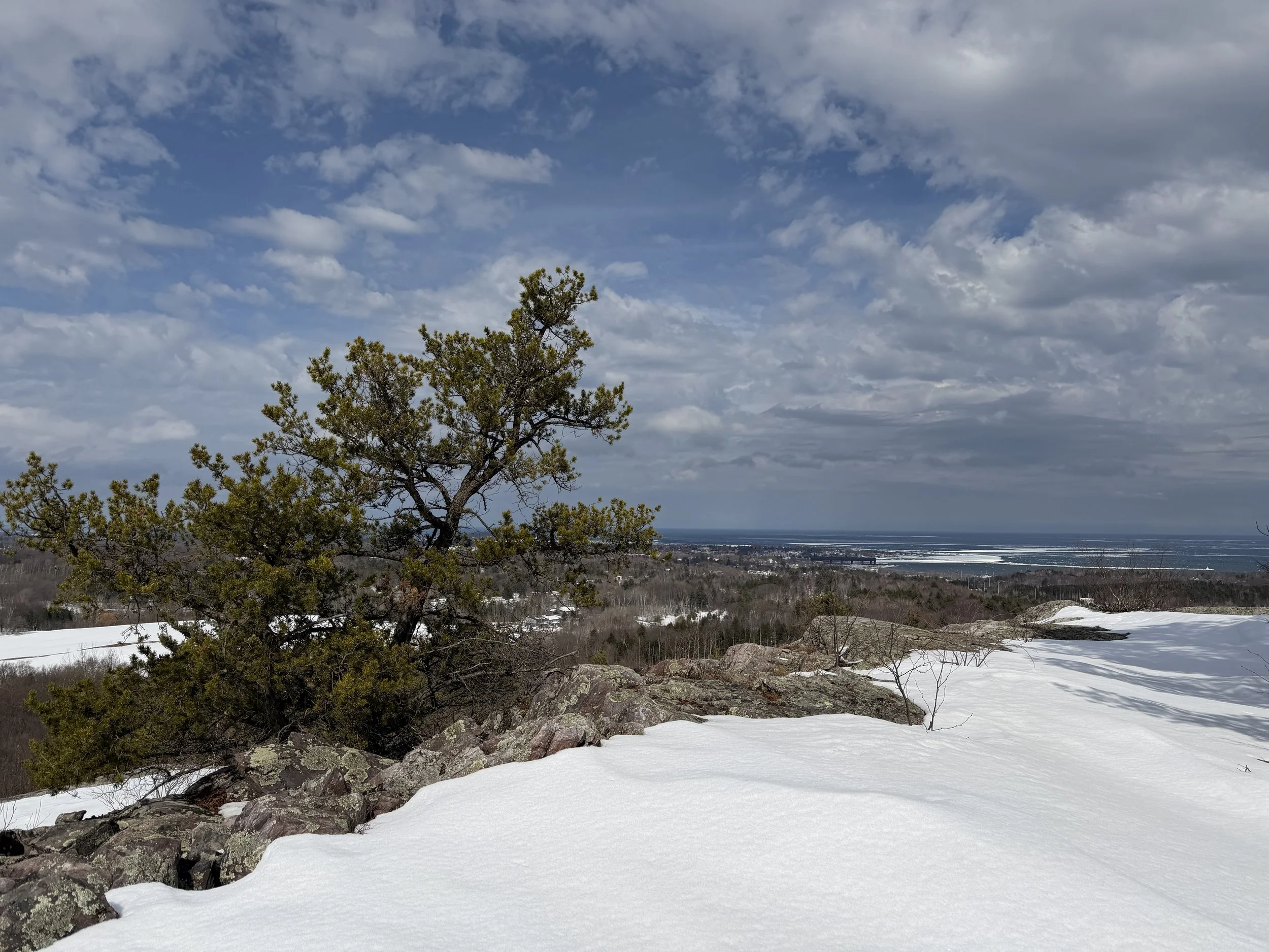
greywalls Ridge
Greywalls Ridge in Winter. Photo by Tony Barnes.
For those who want to get off the beaten path and onto the ancient spine of the region, the Greywalls Ridge is an absolute standout. This route takes you along a dramatic quartzite ridge, offering a rugged and technical experience that feels far more remote than its proximity to town would suggest. It is a geologist's dream and a hiker’s playground, defined by its stark, beautiful rock faces and elevated perspectives.
-
The Greywalls Ridge is easy to get to if you know how to approach it. Climbing the rocks can be as easy or as difficult as you want to make them. This is a technical hike that requires confidence in your footing. While the total distance isn't extreme, the terrain involves navigating steep slopes and uneven rock surfaces that will keep you engaged from start to finish.
-
We move with a steady, athletic energy. Because of the technical nature of the ridge, we keep our momentum up to navigate the climbs, while still pausing at the best vantage points to catch our breath and take in the scale of the landscape.
-
The approach to the ridge is accessible by hiking trail but requires off trail hiking to be able to traverse. We utilize primitive backcountry trails and engage in several rock scrambles, where you'll use your hands for balance as we traverse the exposed spine of the ridge.
-
This quartzite ridge extends across the horizon to include a number of different peaks. The whole ridge system is itself over two miles long!
-
It is easy to spend an entire day exploring the south trails of Marquette. Or, you can add Mt. Marquette to compare the different ways these ancient peaks overlook the city.
Kona Hills
Rock Cut. Photo by Tony Barnes.
Kona Hills offer a unique vantage point that many visitors miss, providing a sweeping look at Marquette from the south. This area is a fascinating blend of natural beauty and rugged geography, featuring impressive rock formations and expansive views that stretch across the city toward the horizon of Lake Superior. It’s the perfect choice for those who want a rewarding "overlook" experience without the intense vertical climb of some of the higher peaks.
-
The summit at Kona Hills is easily the shortest climb of any outcrop in Marquette making it a great option for a wide range of hikers. While there are some steady inclines, the terrain is manageable and doesn’t require the technical scrambling found on more challenging ridges.
-
The natural setting of Kona Hills, located just outside Marquette, forces you to slow down and appreciate the coexistence of the urban environment with the wilderness. The goal is to appreciate the transition from the forest to the open vistas, ensuring you have plenty of time to take in the views and learn about the local landscape at a relaxed speed.
-
The hike is entirely within the Kona Hills Campground, utilizing solid gravel access roads and wider "two-rut" paths. As we reach the higher points, we’ll walk across broad, ancient rock slabs that provide a firm and unique hiking surface underfoot.
-
Take in a stunning, wide-angle view of the Marquette area, explore the dramatic "Rock Cut" where the earth has been split to reveal the stone beneath, and keep an eye out for the majestic local eagle's nest that overlooks the campground.
-
The Bayou is across the highway which makes the connection to Kona Hills quite easy. If you bushwack in the other direction, you can access the South Trails which opens up access to whole other world of outdoor recreation.